Mobile Connections
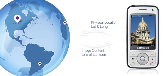
The project aims to highlight the various connections between mobile phone users and their environment by providing a series of applications utilising geo tagged data from a variety of sources. The initial application highlights the similarities in photos taken by tourists at various locations by allowing visitors to take a photo at a specific physical location and be presented with an image taken by another tourist at the same point. Due to the nature of sightseeing there is a high probability that the image will focus on the same object. The second application highlights connections between users in terms of their position on the earth by finding images of interest taken on the same line of latitude. When the user takes the image the highest rated picture geo tagged on the same line of latitude is presented showing what objects of interest are shared with their current position on the earth.
The initial aim in developing these applications was for technical reasons practising Java Micro Edition application development. With this in mind I wanted to create an application that drew on the mobility of these applications and the variety of locations that they could possibly be used in. Therefore by combining the camera with GPS data it allows for clear visual connections to be made between the photographer and the rest of the world.
The applications are written using J2ME and make use of the mobility libraries for access to GPS and camera objects. On the launch of each midlet GPS data of the current location is gathered allowing for later requests to be made to retrieve appropriate images. Geo tagged data is gathered through flickr and returned as a list of appropriate files in the form of XML data. The application then downloads and resizes the images for appropriate display on the mobile device. For the initial application it simply makes Flickr requests with the current GPS data returning geo tagged images closest to the users current position. The second application attempts to find images based on the users line of latitude and so the GPS data is sent to a backend server through standard http requests where flickr requests are then made in turn with a wider radius working along the line of latitude. A random distance is chosen between each request and stops when a sufficient number of images have been returned. This is then in turn sent to the application in XML where it is interpreted leading to a further request for the image from the Flickr servers.
At present the applications are relatively simple and give little further information regarding the presented images. Part of the purpose of the application is to just present clear images without numerous amounts of statistics which detracts from the mystery of the images location. The application could be extended giving information such as the distance from the current user to the displayed content and allowing further image information tags to become visible.
Completion Status
Is It DoneMore Info
Arduino, Picaxe Micro Controller, RF Interface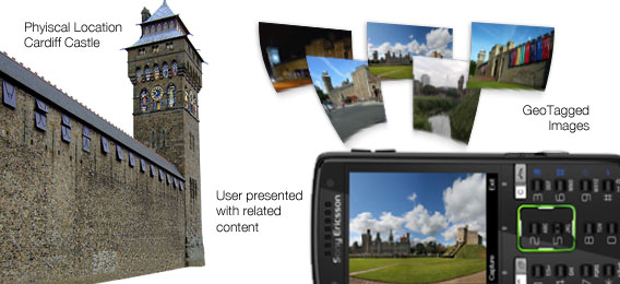
Connected Content